
Low rain has exposed a sinkhole or two on Lake Miccosukee, offering a glimpse into the forces that created our largest area lakes, and their connections to the Floridan Aquifer.
Rob Diaz de Villegas WFSU Public Media
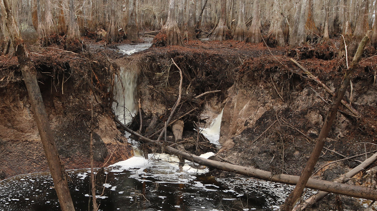
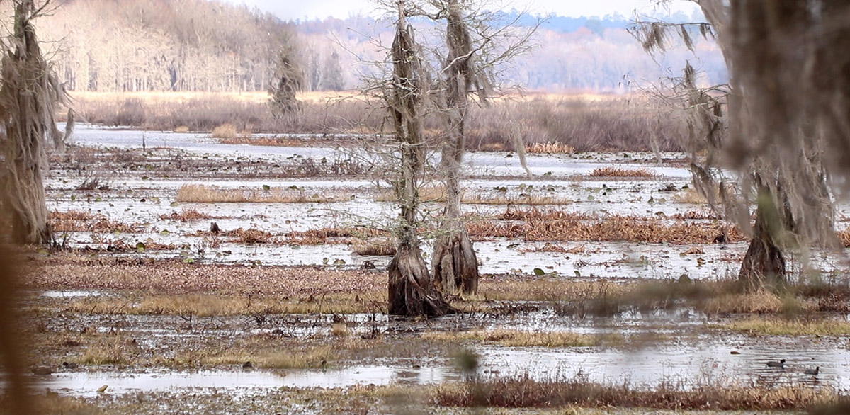
We’re walking on exposed lake bed. The ground is spongey and springy, not a place used to feet pressing down on it. The west edge of Lake Miccosukee is usually kind of a cypress swamp, and in the winter coots issue out of it to forage among the grasses in the open water alongside. Right now, though, the open water looks grassier, and I’m walking in that swamp. Miccosukee’s water is going down a hole.
I’m here with Florida’s Assistant State Geologist, Harley Means. If water’s disappearing down sinkholes, then he’s the one to tell us where it might be going. One possible destination, after it drains into the upper parts of the Floridan Aquifer, is the headsprings of the Wacissa River. And so Kayak outfitter Harry Smith is also with us. We paddled the Wacissa’s springs with him at this time last year; today he might be seeing a source of some of his favorite waters.

Left- Harley Means, Florida Geological Survey. Right, Harry Smith, Tallahassee kayak outfitter.
When we start hearing fast rushing water, Harley warns us about standing near the edge of a sinkhole. This thing is expanding, it’s edge unstable. This is geology happening now, over weeks and not over geologic time. This sinkhole is active.
And because it’s active, it’s drawing in enough lake water for us to walk up and take a look. It’s an opportunity to come face to face with surface water turning into groundwater where we can’t normally see it.
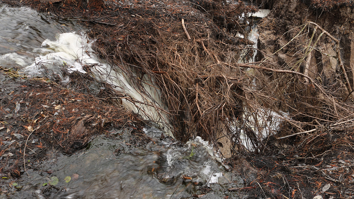
Water gushes through the roots of fallen trees, over the edge and into a sinkhole.
These Sinkholes Are Thirsty, and Growing
Little streams have found grooves in the exposed lake bed, rushing into each sinkhole as waterfalls. Some of these falls are trickles, and some are loud, gushing whitewater beasts. Harley notices that the sinkholes are wider than on his last trip, ten days ago. This has taken out more trees on the sinkholes’ edges.
And we can see from Jeff Erb’s drone footage from earlier on that the water level inside the sink has been getting lower. From what Harley tells me later about a return visit after our shoot, it drops further. This helps us to visualize why the sinkhole became active.
In the video, Harley mentions a rain deficit of late. Partially, it’s that rain has failed to fill the lake; however, levels were also dropping beneath the lake. “So when the water levels in the underlying aquifer drop,” Harley says, “And you’re not getting enough rainfall to fill the basin up, then you’ll get more water focused through the sinkhole. And then at some point, something triggers and the sinkhole opens up.”
So as the aquifer finds itself emptier, the sinkholes get “thirstier” and start draining Lake Miccosukee. The two sinkholes we visit are at its edge, while its main sinkhole is in the northwest of the lake. This larger sink is surrounded by a control structure that keeps water from draining into it, but its gate can be opened manually to allow the lake to draw down.
The southwest corner of Lake Miccosukee. The water is lower than usual, but a dam is preventing the lake from a full draw down. Just to the left, two sinkholes have become active.
It was a scary sight to those who constructed the dam in 1954; the water was gone, and fish flopped on empty lake bottom. If the structure were to be opened now, given the current fullness of the aquifer, we might see that again today.
The plant and animal communities of the lake evolved with this process over thousands of years, as biologist Michael Hill explains below. It’s a process that had played out in each of our area’s four big prairie lakes. And, as Harley explains, it’s this process that created these lakes.
Lakes Created From Below
Leon County is home to three of the lakes: Iamonia, Jackson, and Lafayette. Lake Miccosukee sits at the border of Leon and Jefferson, and the water is for the most part in Jefferson.
Standing here next to these sinkholes, we can see the mechanism that created them. Think of that thirsty aquifer. Over thousands, possibly millions of years, sinkholes opened up when the aquifer was low. Over that time, many smaller sinkholes coalesced and the aquifer would cave in. This created low spots on the landscape.
As with any river or stream, water collects in low spots, and so these basins became lakes. Each lake drained at somewhat regular intervals, as natural climate cycles of wet and dry years filled and emptied the aquifer beneath it. Right now we see that the sinkholes are still active. The process continues- to an extent.
Lake Miccosukee’s main sinkhole has that control structure, as does Lake Iamonia. Lake Iamonia’s dam is no longer functional, but the lake is still in need of some restoration for its ecology to function as it once had.
And then there’s the case of Lake Lafayette, which was segmented by earthen dikes to create four separate water bodies. Two of these are among Tallahassee’s most impaired lakes: Piney Z. and Upper Lake Lafayette, which is home to the original lake’s sinkhole.
This altered hydrology of our biggest natural lakes has created issues at two levels. One, the lakes no longer function as they once had, necessitating expensive restoration efforts. The second issue is that troubled water in the lake connects to other waterways through the aquifer.
We’ll take a look at both issues in the following sections. I also recommend taking a look at our 2016 Lake Report, where we detail Leon County’s sampling of area lakes.
So What Happens to Prairie Lakes When They Don’t Empty?
We first started talking about this in 2013-14, when we went to Lakes Lafayette and Iamonia with now retired Florida Fish and Wildlife biologist Michael Hill. Below are a couple of clips from our Lake Iamonia shoot. We covered a lot in that segment, and so I didn’t use a lot of these interviews then. Luckily, they fill in some knowledge that is useful in understanding our Red Hills prairie lakes.
Quickly, here’s what Michael says:
- He estimates that when lakes drew down, only about 5% of their water went down sinkholes.
- He mentions Lake Miccosukee’s dam, and how keeping the water in has expanded the lake savannah “from 100 acres to 6100 acres.” He credits this as a plus for waterfowl and fish, which are both important to recreation on the lake.
- Michael thinks that the dam could be a good management tool, but notes the following paradox. People like to keep the dam closed when water is low, because it keeps recreational users able to use the lake. In fact, when out with Harley, we could hear rifle blasts from duck hunters. But this is when the lake would naturally have drawn down, and it does need to draw down periodically. “Every time we get people saying ‘Why don’t you do something about those tussocks?’ ‘Well, we need to do a drawdown.'”
Let’s talk more about tussocks and muck:
In the first clip, Michael mentions muck and tussocks. Here, he talks about how muck builds up.
- Drought cleanses the lake bottom. “The rapid growth of aquatic plants, as they go through their life process, build a muck layer.” Think of the decomposing plant matter in a swamp, leaves breaking down and making muck. When that muck is exposed to sun and air, it dries and stays at a manageable level.
- Michael estimates that Lake Iamonia has between 2-4 feet of muck. Even though the dam broke, the lake didn’t drain for fifty years. As he said in the first video, it could take another 50 years of going through wet/ dry cycles for it to return to what it had been.
- When we visited Lower Lake Lafayette with Michael, he showed us what happens when muck sits and thickens. “The bottom eventually fills up with dead organic material- old plants- and eventually it’ll gas up and float.” Seeds take root in these floating islands, and trees and other plants start to grow where there should be open water. After that shoot in 2013, FWC spent millions of dollars to clear these tussocks. But the dams separating Lake Lafayette will still keep the lake from draining, and so muck will still accumulate.
Floating mats of vegetation- tussocks- on Lower Lake Lafayette, 2013.
We can see how geology has shaped the way these lake work. Now, let’s explore what’s going on beneath the lakes.
Sinkhole Spelunking and Dye Traces
In 1999, Lake Jackson drew down. The water completely and thoroughly disappeared, enough that Harley Means was able to climb down in and explore Porter Sink with the Florida Geological Survey (FGS).
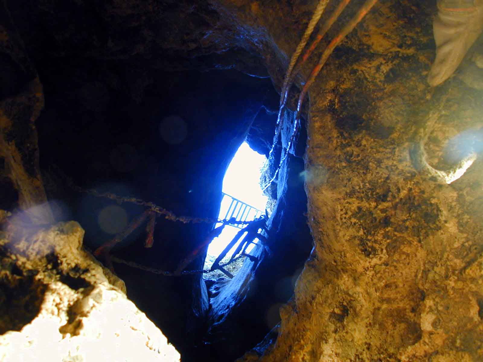
The view looking up out of Porter sink, Lake Jackson’s main sinkhole. Photo courtesy Florida Geological Survey.
In the video, Harley mentions that our sinkhole lakes’ water first drains into the upper Florida Aquifer. The aquifer, in its entirety, is huge. It underlies all of Florida, and parts of Georgia, Alabama, Mississippi, and South Carolina. It’s where we get our tap water in Tallahassee; and if you like bottled water, some of that comes from there as well.

Right now, in 2018, this cave under Lake Jackson is filled with water. Photo courtesy Florida Geological Survey.
But the Floridan Aquifer isn’t one giant water cave. It’s made up of many different units, some closer to the surface and some deep below. The FGS mapped the caves directly beneath Lake Jackson, and were able to reach four levels down before hitting water.
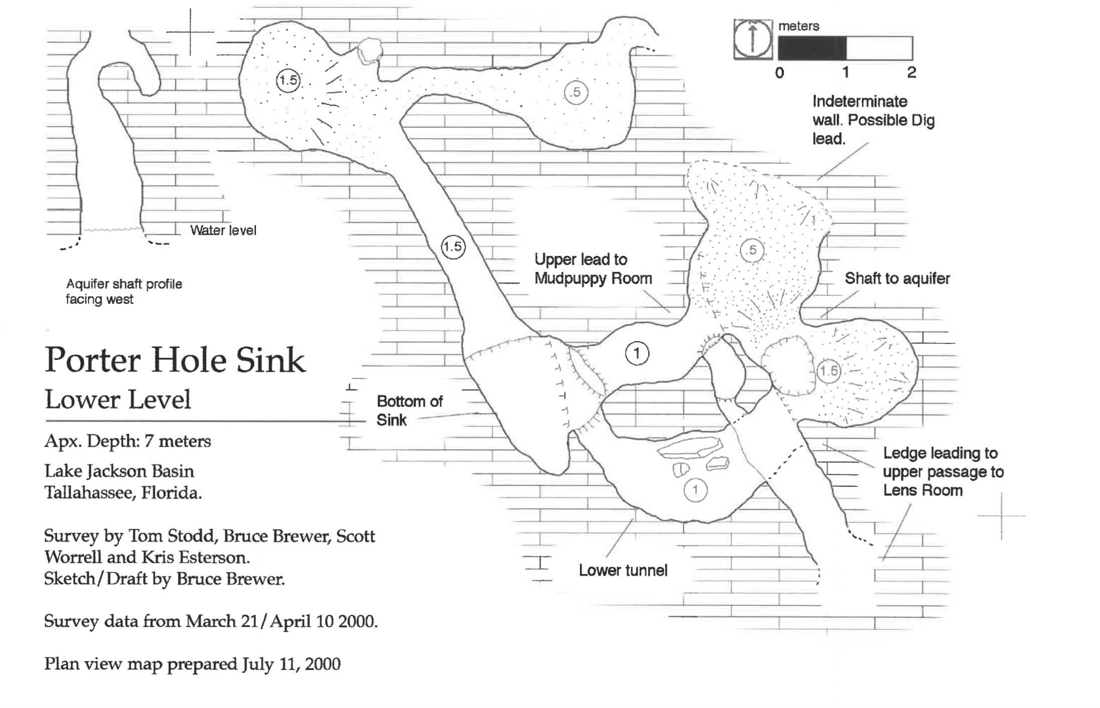
A map of the lower level of Porter Sink, provided by the Florida Geological Survey.
So here we see where water enters the aquifer, but where does it go from there? Most of the aquifer isn’t so accessible. The Woodville Karst Plain Project has been diving sinks and springs in the Wakulla Springs system, and they’ve been mapping those caves. But much of that underground network isn’t necessarily explorable by humans.
It makes sense that Red Hills sinkhole lakes might have connections to Wakulla Springs, or springs in the St. Marks or Wacissa Rivers. So how do we connect the dots? One answer is dye traces.
Harley mentioned this as we stood by the Miccosukee sinkholes. Those sinks are north of Wacissa’s headwater springs, as well as some that feed the St. Marks. Harley thinks it would be interesting to send dye into these sinks to establish a definitive link between these waterways. Recently, Dr. Sean McGlynn conducted similar studies on two other Red Hills lakes.
The Wakulla Springs Connection
While Lake Miccosukee lies to the north of the Wacissa and St. Marks Rivers, the Leon County lakes are north of Wakulla Springs. McGlynn Laboratories conducted two dye traces (PDF) for the Wakulla Springs Alliance on Upper Lake Lafayette, and in Porter Sink on Lake Jackson.
They first chose dye colors not used in previous studies by the FGS. Then they sent the dyes down from a boat, while divers guided tubes into the sinkholes. They detected dye from both sinks in Wakulla Spring after 35 days, and dye from Lake Jackson in Sally Ward Spring after 31 days.
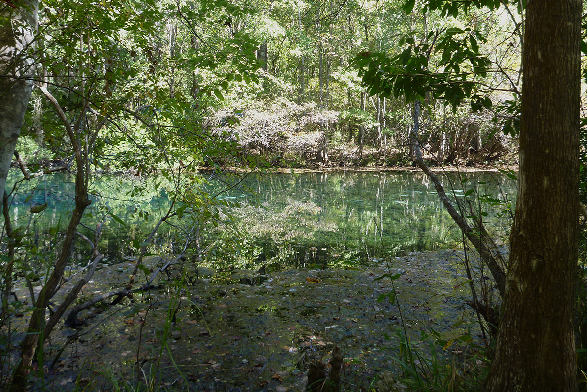
Sally Ward Spring, a smaller spring next to Wakulla Spring, which also feeds the Wakulla River.
As we found when we followed the path of water to Wakulla Spring with Jim Stevenson, water moves in and out of several sinks and springs on the way to Wakulla, which is the largest spring in North America. Dr. McGlynn found dye in those water bodies as well.
The title of Dr. McGlynn’s study is Wakulla Spring Dark Water: Causes and Sources. He doesn’t draw conclusions about why Wakulla Springs water has darkened over the last few decades, but the connection between these lakes and the spring gives us a reason to look at the water in these two lakes.
Leon County’s sampling of the lakes in recent years has shown them to be above threshold for nutrients such as chlorophyl a, total nitrogen, and phosphorous (as we see in the 2016 Lake Report). These feed the kind of algae that has troubled Wakulla Spring in the last couple of decades.
While Lake Jackson’s issues aren’t the result of lake modifications, you can make the case that Upper Lake Lafayette wouldn’t be as impaired if wasn’t dammed from the rest of the original Lake Lafayette. Both Upper Lake Lafayette (300 acres) and Piney Z. Lake (228 acres) have been troubled by runoff and algae blooms. Lower Lake Lafayette is over 1,000 acres, and has cleaner water, even if it does develop tussocks because it’s disconnected from the sinkhole. In a contiguous lake of over 1,500 acres, nutrients would likely become more diluted and perhaps send cleaner water towards Wakulla Spring.
Salamander Geology

Harley and Ryan Means inside of Porter Sink.
This photo of Harley and his brother, biologist Ryan Means, got me thinking about how geology shapes other waterways in our area. For instance, a couple of years ago, we spent a day with Ryan and his wife, Rebecca, releasing endangered striped newts in the Apalachicola National Forest.
Striped newts breed in ephemeral wetlands, shallow ponds that fill and empty as the underlying water table fills and empties. There’s no sinkhole or spring, but they resemble our sinkhole lakes in that their fullness is tied to the amount of rainfall that collects in the aquifer. As we see in the blog post I wrote about it (linked above), striped newts became extinct in the ANF because a dryer climate in recent decades kept wetlands dry for so long that newts couldn’t breed.
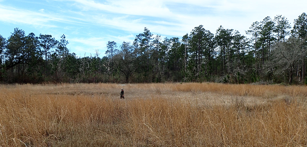
Ryan Means crosses an ephemeral wetland in the Munson Sandhills region of the Apalachicola National Forest. Water was low in 2017, and many of the wetlands in this area dried up.
Surprisingly, salamanders seem to be a good way to look at geology and wetland environments. Last summer, I went out with Harley and Ryan’s father, Dr. Bruce Means. He had, over the course of 50 years, discovered a couple of salamander species dependent on specific geological features, seepage slopes and steephead ravines. The water flowing from those doesn’t come from the Floridan Aquifer, but from smaller aquifers trapped in bluffs above rivers. Each geological feature created, over geologic time, its own type of wetland suitable for these salamanders.
Geology shapes biology, and vice versa. The limestone that makes up the Floridan Aquifer is made up of shellfish that lived in a shallow sea that covered the American southeast millions of years ago. It’s amazing to me.
Yes, our lakes and steephead ravines and everything else formed over incomprehensible lengths of time. But, standing here on the west edge of Lake Miccosukee, we can see geology happening now.

WFSU Producer Rob Diaz de Villegas.