
Leading up to the latest Florida/ Georgia Water Wars trial, we begin a two part look at the Apalachicola River and Bay. In today’s video, we explore a critical component of the watershed: Tate’s Hell and the Apalachicola River delta. The wetlands and waterways of the delta are key to the success of the Apalachicola oyster, and they’re fun to explore. As for those oysters, watch Local Routes at 8 pm ET on October 27 for a look at the recovery of fishery, which has been reeling since droughts in 2012.
The banjo tunes you hear in the video were composed by Chris Matechik. We last heard Chris jamming at Owl Creek on RiverTrek 2015 (with 4-year old Max dancing along). Chris is a marine technician at the FSU Coastal and Marine Laboratory.
Rob Diaz de Villegas WFSU-TV
Today on our Tate’s Hell kayaking trip, we’re heading off the trail map. Specifically, I’m looking at Florida Fish and Wildlife’s map of paddling trails in the Apalachicola River Delta. The suggested trips all head away from Tate’s Hell State Forest, while many waterways heading into the forest end in questions marks. It looks like we’re paddling into the unknown. And yet, that’s where we want to go to get a firm grasp of the river delta’s inner workings.
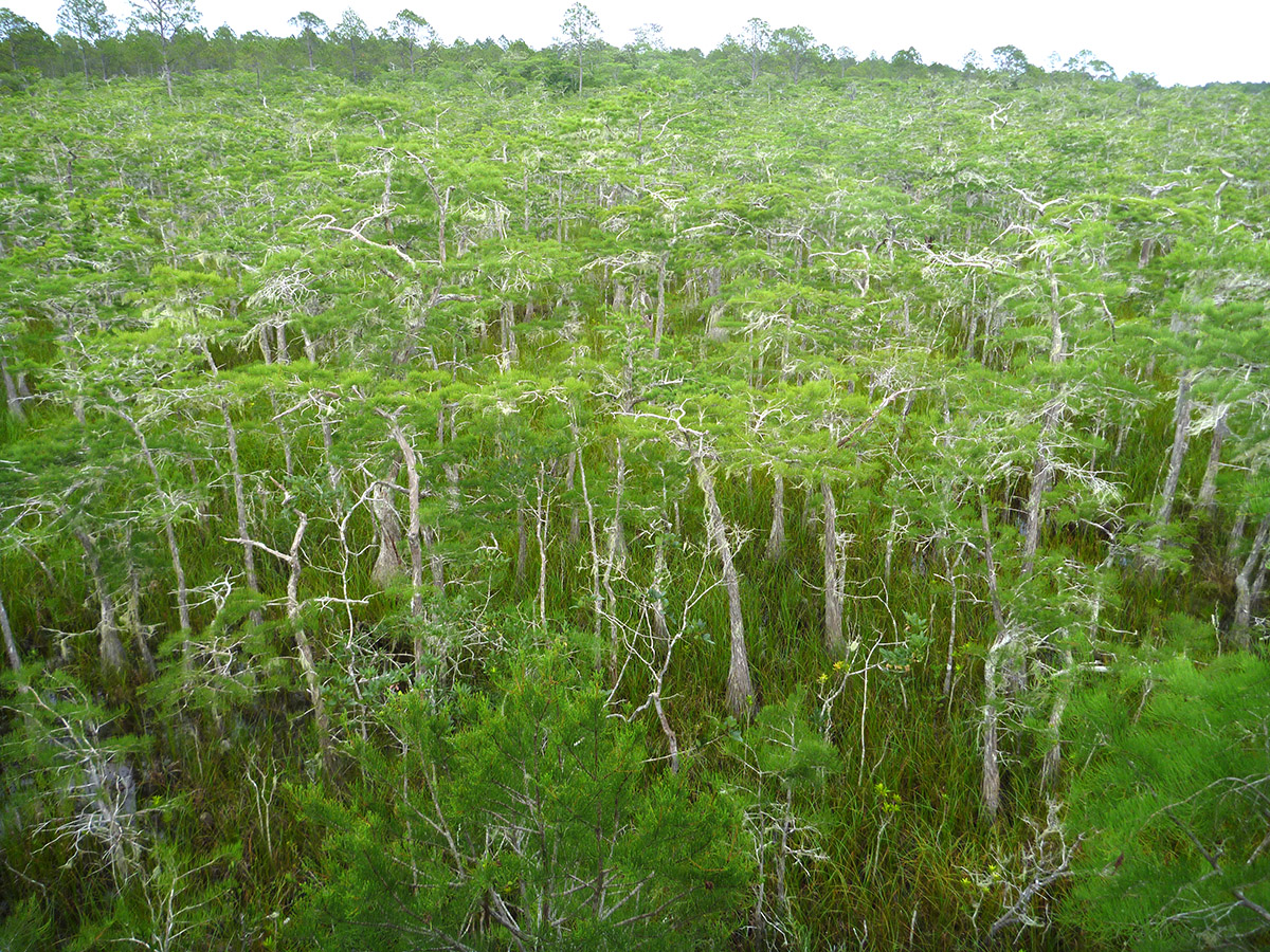
Dwarf cypress forest in Tate’s Hell State Forest, as seen from the Ralph G. Kendrick Boardwalk. Many of these trees were alive when Cebe Tate got lost hunting down a panther here- 150 years or older. This is one of the many wetland habitats feeding East Bay, and ultimately, Apalachicola Bay.
Listening to Doug Alderson’s story in the video above, or even just hearing the name Tate’s Hell, you get a sense that the place is mysterious and impenetrable- you enter at your own risk. But Cebe Tate made his now famous journey in the 1870s. Then, Florida panthers still roamed the panhandle, and Cebe set off without the benefit of GPS or satellite accurate maps. Cebe Tate’s personal hell was all question marks.
So, sitting here in 2016, why does my map have question marks?
We like to look to maps for a well defined, concrete sense of place. Blue lines and shapes are water; and when we see these lines on paper we might intuitively consider them fixed boundaries. But that’s just not the case. Especially when it comes to swamps.
That’s because every year during the rainy season, the Apalachicola River swells. Its water seeps into and fills sloughs and swamps. Many of these wetlands are disconnected from the river during the drier parts of the year. When the river floods, the system becomes fully connected. Fish have more places to forage, and bugs on the newly drowned shore become fish food. When the water levels go back down, nutrient rich muck in these wetlands (decomposing plant matter filled with nitrogen), gets pulled into the main river channel and flushed into Apalachicola Bay. There, it feeds oysters and all of the other plants and animals at the bottom of the estuary’s food web.
The question marks on the map tell us that there are no guarantees about how much water we’ll have at any given time, or for how long these smaller channels will be navigable. In an age where we can plot the course of waterways from outer space, heading into those question marks is still a real adventure. And it’s a cool lesson in the living, breathing nature of the Apalachicola watershed.
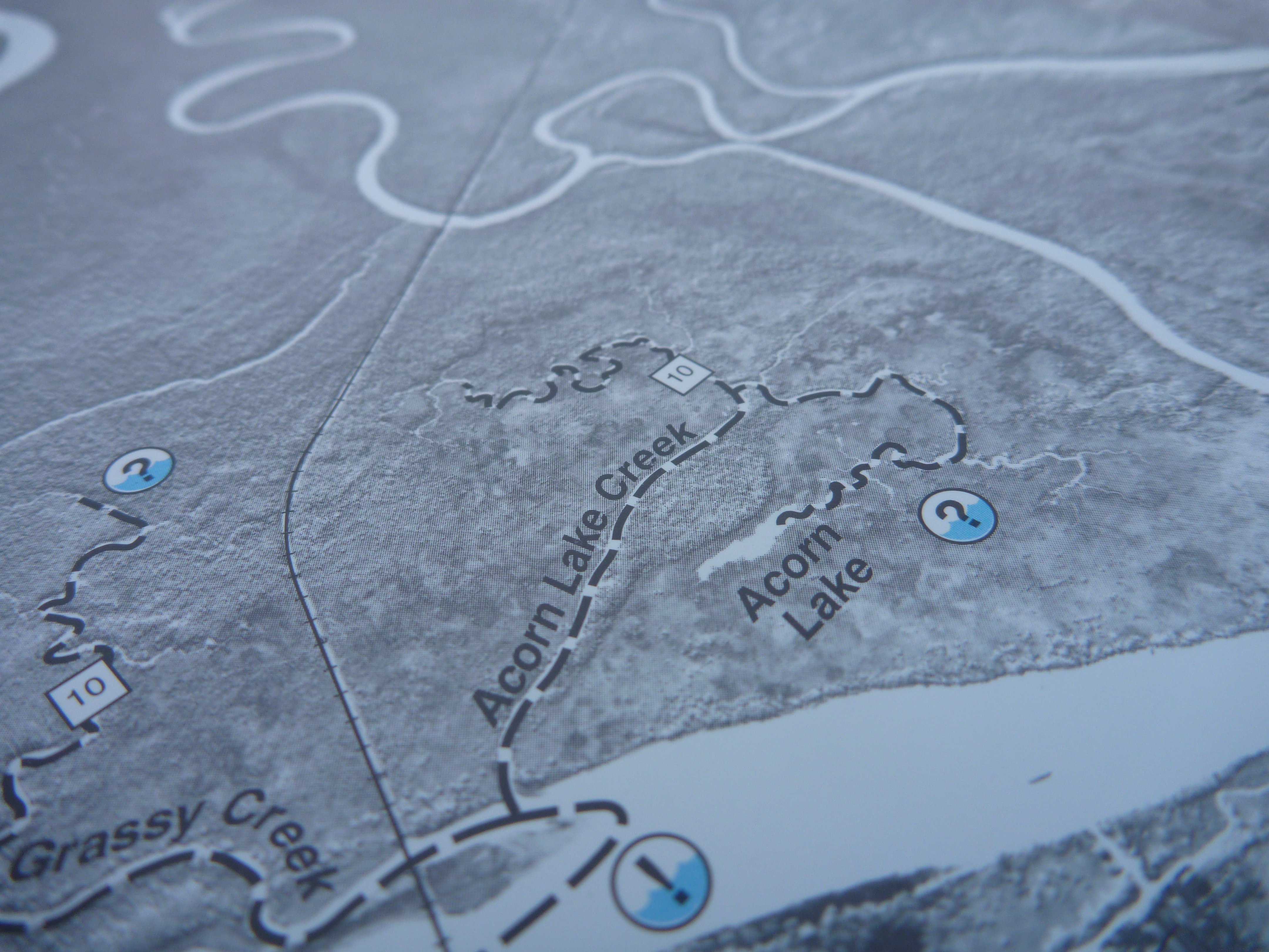
The Apalachicola River WEA Paddling Trail System map. The question marks are where the trail may or may not be there, depending on rainfall, while the exclamation points signify that you may encounter larger watercraft, and to be cautious.
Kayaking Graham Creek into Tate’s Hell
The FWC map I’m consulting is one you can purchase from them, though the individual trip plans it highlights are available on their website. The Graham Creek trips are similar to the one mentioned by Apalachicola Riverkeeper Dan Tonsmeire in our video. They all head out into the East River, into more open waters and more possible connections to other waterways. On our Graham Creek adventure, we headed the other way.
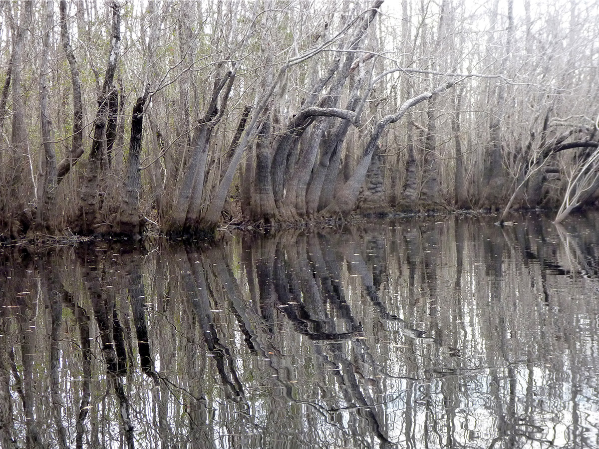
Bare tupelo trees in Graham Creek, January 2012.
If you paddle the same swamp more than once, during different seasons or in different years, you’ll likely see a different place. When I had previously kayaked Graham Creek in 2012, it was in the winter. The ogeechee tupelo trees were bare; branches arched like skeletal fingers around us. In June of 2016, we not only had leaves, but the last of tupelo flowers were wilting and falling off the trees.
This June, we also had more water in the swamp. In January of 2012, the Apalachicola River registered an average of 9,974 cubic feet per second (cfs) at the Sumatra Gauge. We know that 2012 was a historically low year for the river. Data from that gauge is only available through February 2016, but Dan Tonsmeire had it at about 18,000 cfs around the time of our current trip. We were able to penetrate more deeply into the swamp. In the video, you can hear RiverTrek coordinator Georgia Ackerman say “I’ve never been back this far!”
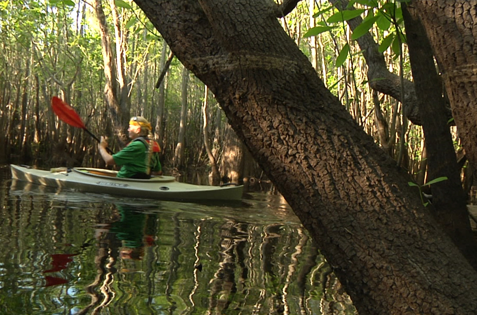
Robin Vroegop paddles past a tupelo tree with a high watermark.
Also in the video, you can see evidence that the water had been higher still. We see it one shot where Robin Vroegop paddles past a tree with watermarks around her head. In December of 2015, the river was at an average of 34,790 cfs. In January, it was was nearly double that at 79,410. Winters are typically a dry time of year, but it hasn’t been a typical year.
Visiting the Apalachicola’s swamps and noticing these differences, and then correlating them to the numbers, we can start to get a sense of the river system’s fresh water needs. It’s not just about how much water, but also, how much water, when. Life has adapted to these river cycles, and it needs both its high and its low periods.
Tate’s Hell State Forest offers much more recreationally than kayaking. Check out their official website for more information on hiking trails, and some other uniquely north Florida habitats to explore.
RiverTrek: Educating the Apalachicola River’s Ambassadors
As we head further into the Tate’s Hell swamp, our passage narrows and it’s a little more work to make those tight turns. But that’s okay; we have an experienced group today.
If you’ve kept up with our EcoAdventures segments in recent years, you may recognize many of their faces. It’s a team of current and former RiverTrekkers, a group with whom I have spent many hours on the Apalachicola. RiverTrek is Apalachicola Riverkeeper’s annual adventure fundraiser. For those who don’t know, every October, a dozen or so volunteer kayakers make their way down the entire Apalachicola River. That’s a 107 mile journey from the Jim Woodruff Dam to the John Gorrie bridge in Apalachicola.
The money they raise helps the Riverkeeper fund their outreach and advocacy efforts. But RiverTrek does more for the Riverkeeper than raise money. The trip itself is a huge outreach and education tool. By inviting members of the media, images and information about the river basin gets out to the public. That includes the videos we produced on our three trips. Additionally, RiverTrekkers receive the best kind of hands on learning, and become ambassadors of the Apalachicola.
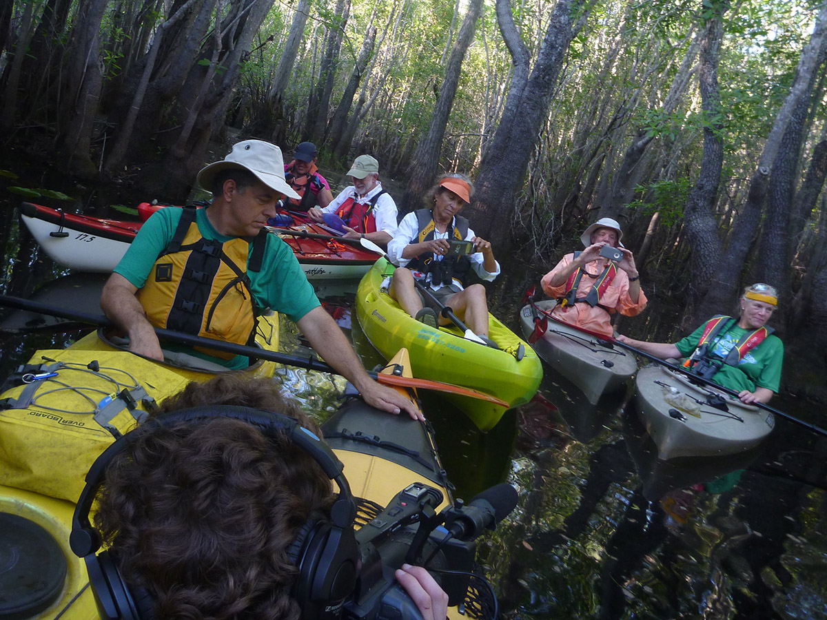
From left to right: Doug Alderson, RiverTrek co-coordinator and veteran of multiple ‘Treks; Katie McCormick, who is getting ready for her third ‘Trek and who sits on the Riverkeeper Board of Directors; Patrick Madden, preparing for his first RiverTrek; Riverkeeper supporter Karen Berkley; and Mike and Robin Vroegop, who completed RiverTrek 2015 on their sail kayak.
Part of that education comes from the experts that we meet along the way. The 2016 expedition is slated to include Tall Timbers’ Kim Sash, FWC biologist Pierson Hill, retired FWC biologist Michael Hill, biologist Todd Engstrom, and geologist Harley Means. Yes, those links are all to adventures we’ve had with those folks! And Doug Alderson will be along to lead the trip and share his history knowledge (Like this blog post, where he goes into some more detail about Cebe Tate and others who toiled in his hell).
Now, history and biology could always be taught in the classroom. RiverTrek, however, is about the experience. Seeing the river, all of it, helps put the facts we learn into context. And, we get a broader picture of the river on side trips which vary from year to year. We’ve explored tupelo swamps, bushwhacked through Torreya State Park, and hiked into the floodplain forest to find a spring.
This exploration of the river and its wetlands isn’t contained to single week on the water. In 2014, Doug organized a river walk along the many protected lands around the river. Like in the video above, we saw some of the “backstage” of the Apalachicola River system. Last year, a team of cyclists rode alongside the river, checking out the communities around it. And then there are trips like this one. Exploring Tate’s Hell fills in one more piece of the Apalachicola puzzle, further deepening our connection to its waters.
Coming up for the Apalachicola
- Thursday, September 29 at 11 am ET: Members of the RiverTrek team join Tom Flannigan on WFSU-FM’s Perspectives.
- Tuesday, October 11: RiverTrek 2016 kicks off in Chattahoochee, Florida.
- Saturday, October 15: 107 miles later, RiverTrek 2016 arrives in Apalachicola.
- Thursday, October 27 at 8:00 pm ET: We take a closer look at the recovery of the Apalachicola Bay oyster fishery on WFSU-TV’s Local Routes.
- Monday, October 31 at 8 am ET: The states of Florida and Georgia meet in U.S. District Court in a battle over fresh water in the Apalachicola/ Chattahoochee/ Flint basin.
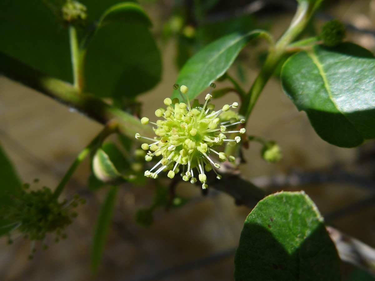
A Tupelo flower on the Brothers River, a distributary of the Apalachicola. In the video, we also visit Graham Creek and Owl Creek, prime examples of tupelo swamps. These wetlands are important to the Apalachicola estuary, and economically important on their own. Tupelo honey is a premium food product, known for not crystalizing.

Heading south on the St. Marks River, trees give way to marshes. Marshes filter water and serve as a nursery for commercially fished seafood species. This distributary shares a name with the St. Marks River that flows south of Tallahassee.